


20190817 Monétier Vallouise

Childebert
User
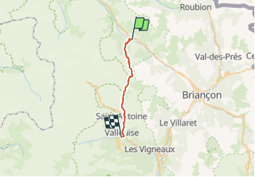

Length
21 km

Max alt
2428 m

Uphill gradient
998 m
Km-Effort
35 km

Min alt
1149 m

Downhill gradient
1307 m
Boucle
No
Creation date :
2019-08-17 05:42:27.94
Updated on :
2019-08-21 14:05:42.219
8h28
Difficulty : Difficult

FREE GPS app for hiking
 SityTrail
IGN / Geographical institutes
SityTrail Plus
The world is yours!
About
Trail Walking of 21 km to be discovered at Provence-Alpes-Côte d'Azur, Hautes-Alpes, Le Monêtier-les-Bains. This trail is proposed by Childebert.
Photos


Positioning
Country:
France
Region :
Provence-Alpes-Côte d'Azur
Department/Province :
Hautes-Alpes
Municipality :
Le Monêtier-les-Bains
Location:
Unknown
Start:(Dec)
Start:(UTM)
303456 ; 4983012 (32T) N.
Comments